Showing 392 items matching land sales
-
 Ringwood and District Historical Society
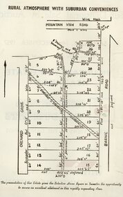
Pamphlet - Land Sales Brochure, Orchard Grove , Heathmont land sales
... Land Sales Brochure...Orchard Grove , Heathmont land sales...Land sales pamphlet with hand-drawn 22 allotments...Land sales pamphlet with hand-drawn 22 allotments ...Land sales pamphlet with hand-drawn 22 allotments of the Estate, Orchard Grove, Heathmont. Also showing Barnic Road and Mountain View Road. Maybe circa 1950s. -
 Bacchus Marsh & District Historical Society
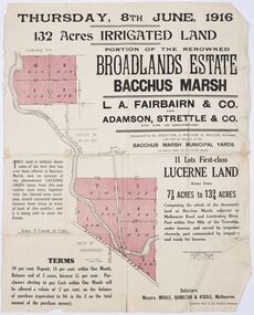
Map - Land Sales Plan, Broadlands Estate, Bacchus Marsh, 1916
... Land Sales Plan...Land Sales Bacchus Marsh...This land sales map was produced by real estate agents...Paper printed land sales map...This land sales map was produced by real estate agents ...This land sales map was produced by real estate agents for an auction of part of a property near Bacchus Marsh known as the Broadlands Estate. 132 acres of irrigated land in 11 separate lots was to be auctioned on the 8th of June 1916. On the 27 May 1916, nine of the 11 eleven lots were withdrawn from sale. The reason stated was due to "road and severance difficulties", according to a notice in the Bacchus Marsh Express newspaper on 27 May, 1916, page.2. When the sale took place on 8th June the two lots were passed in but the local newspaper reported they were expected to be sold privately, see Express, 17 June, 1916, page. 2. The Broadlands Estate was owned by the Miller family whose father Henry Miller, 1809-1888, was a politician and an immensely wealthy financier in Victoria.A typical example of a land sale map of this era. The Broadlands Estate was just over 2,000 acres at its its peak size and was a significant holding of land in the Bacchus Marsh district. Paper printed land sales mapbroadlands estate bacchus marsh, land sales bacchus marsh, farms bacchus marsh, henry miller 1809-1888 -
 Bendigo Historical Society Inc.
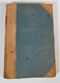
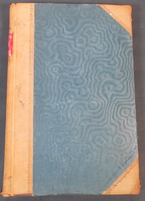
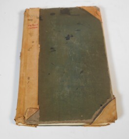
Administrative record - Land Sales Register
... Land Sales Register...land sales... details, and glued in posters of land sales associated... of 'Castlemaine.' Written onto the spine is written in blue texta, 'Land...land sales Register Castlemaine Scratched on the front ...Large cloth bound ledger, hard board cover, front and back. Over a hundred pages not all numbered. Handwritten. Dates from 1906 - 1922. ledger filled with names, addresses, financial details, and glued in posters of land sales associated with clients. Castlemaine is listed as the area for the ledger and also St Anaud, Maryborough, Avoca, Inglewood, Dunolly, Daylesford, Maldon, Heathcote, Woodend. Scratched on the front cover is a faded reading of 'Castlemaine.' Written onto the spine is written in blue texta, 'Land Sales, C'Maine,' and also '8.6.1906 to 23.2.1922.' land sales, register, castlemaine -
 Whitehorse Historical Society Inc.
Document, First Land Sales in Nunawading, 1855
... First Land Sales in Nunawading...Land sales...First land sales and prices in Nunawading.... Mitcham melbourne Document Document First Land Sales in Nunawading ...First land sales and prices in Nunawading.First land sales and prices in Nunawading.First land sales and prices in Nunawading.land sales, land subdivision, middleborough road, nunawading, koonung creek, canterbury road, whitehorse road, holland john, burrell charles, riley james, wilks joseph, springvale road, o'connor patrick, williams william, heading william, blood thomas, cook james, whitman fred, cook charles, kefford r, wilton edward, cousens james, riley patrick, lobb john, orr joseph, woods john, morton william, clisby william, polak nelson, tranter william -
 Bendigo Historical Society Inc.
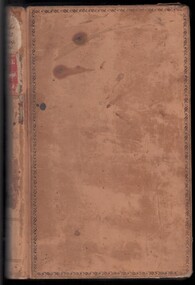
Legal record - Ledger of Reports of Land Sales by Auction
... Ledger of Reports of Land Sales by Auction ...Land sales...Blue and light brown ledger of land sales reports during...Ledger of Reports of Land Sales by Auction Legal record ...Blue and light brown ledger of land sales reports during 1898 to 1924. Blue water marked cover with light brown spine and corners, with red label on spine noting "12". Contains Crown Lands sales by auction documents, including purchasers' names, land section, allotment numbers and price. Ledger of Land Sales Reports 1915 sample reports of Colbinabbin, Kyabram & Rochester.land sales, auction -
 Bendigo Historical Society Inc.
Legal record - Register of Special Land Sales Castlemaine, 28/06/2007
... Register of Special Land Sales Castlemaine...Land Sales...; and label on spines stating "3 and Register of Special Land Sales...Register of Special Land Sales Castlemaine Legal record ...Light brown suede leather cover with ornate embossed edging; and label on spines stating "3 and Register of Special Land Sales". Land sales between 7/03/1862 to 20/04/1869, Castlemaine District on spine. Fine black handwritten entries. First page notes Report of a Sale on the 7th March 1862, in terms of Gazette notice of 7th July 1862. Sale conducted by Public Auction by Thomas Couchman Esq. Acting D.S.land sales, castlemaine, 1860s -
 Bendigo Historical Society Inc.
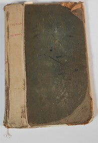
Administrative record - Land Sales Register
... Land Sales Register...Land Sales...Large land sales ledger with cloth binding on spine. 101...Land Sales Register Administrative record Large land sales ...Large land sales ledger with cloth binding on spine. 101 pages handwritten. Dates from 1908 - 1934. Ledger filled with names, addresses, financial details and remarks regarding clients. Ledger for Bendigo area.On front cover page written in red is '138 Front' and '130 Rear.' On the spine it is written in red, 'Bgo 130 +138, 138 Front, 130 Rear, 1 to 500.' On first page written in red "SEC 138 Front." Back cover is written '121 in back of book.'land sales, register -
 Bendigo Historical Society Inc.
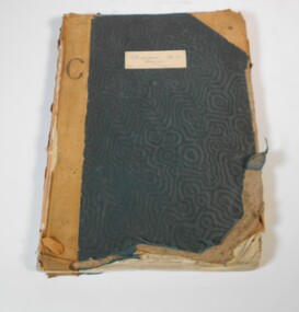
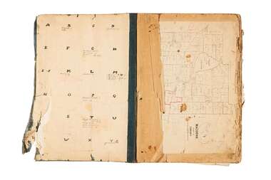
Book - Land Sales Register - Castlemaine sec. 12
... Land Sales Register - Castlemaine sec. 12...Land Sales... is a register of land sales. The sales are recorded in alphabetical...Land Sales Register - Castlemaine sec. 12 Book Book has ...Book has a blue cover and brown leather spine. The book is a register of land sales. The sales are recorded in alphabetical order. The records give the number of the application, the date of registry, the date of application, the surname of the purchaser, the Christian name and address, the parish, allotment, section and area, the decision, special condition, the license and remarks. The book covers the years from 1896 to the 1940's. On the cover a white sticker with the words: "Castlemaine Sec 12 register" and in texter the number 26 and letter C. On the spine "S 12 171"land sales, castlemaine -
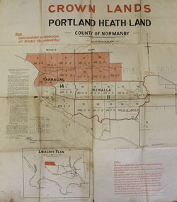 Ballarat Diocesan Historical Commission
Poster, Government Land Sales Poster
... Government Land Sales Poster.... Land Sales, Portland....Government poster advertising land sales to promote closer... Ballarat goldfields Poster Government Land Sales Poster Government ...Government poster advertising land sales to promote closer settlement in Portland area. The acquisition of land for the purpose of closer settlement was first authorised under the provisions of the Land Act 1898. In 1917 under the provisions of the Discharged Soldiers' Settlement Act, the scheme reverted to the Soldiers' Settlement scheme when the government undertook the settlement of discharged soldiers on lands set aside exclusively for them as a reward for their war service.closer settlement, soldiers settlement, government poster. land sales, portland. -
 Ringwood and District Historical Society
Envelope, First land sales in Ringwood 1858
... First land sales in Ringwood 1858...First land sales in Ringwood 1858... Road Ringwood North melbourne Envelope First land sales ...First land sales in Ringwood 1858 -
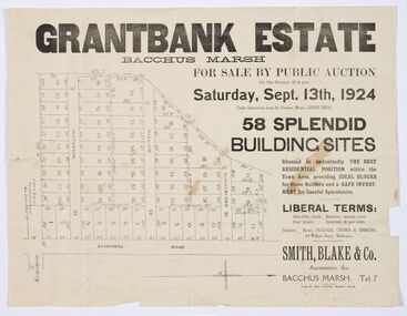 Bacchus Marsh & District Historical Society
Map - Land Sales Plan, Grantbank Estate Bacchus Marsh, 1924
... Land Sales Plan...Land Sales Bacchus Marsh... map is a typical example of housing estate land sales ...The Grantbank Estate was a parcel of land close to the centre of the shopping area of Bacchus Marsh which was sub-divided and offered for sale in 58 lots on the 13th September, 1924. It comprised an area of 15 acres, being a portion of the Millbank Estate which had been in the hands of the Grant family for 75 years. The lots had frontages to Gisborne Road, Patterson, William and Sutherland Streets. This was a significant sub-division of land and represented a major expansion of residential housing in Bacchus Marsh in the early 20th century.This land sale map is a typical example of housing estate land sales advertising maps produced by real estate agents in this era. The map is significant for the detailed information it provides about when and where land was sold for new housing estates in Bacchus Marsh in the early twentieth century.Printed paper mapland sales bacchus marsh, land subdivsion bacchus marsh, housing estates land sales bacchus marsh, grant family bacchus marsh -
Greensborough Historical Society
Document - List, Peter Simmenauer et al, Hobson land sales
... Hobson land sales...2 p. list of land sales, with 2 p. copy of LP11599, Vol...subdivision plans greensborough 2 p. list of land sales ...2 p. list of land sales, with 2 p. copy of LP11599, Vol. 2340 Fol.805subdivision plans, greensborough -
 Bendigo Historical Society Inc.
Book - Land sales applications
... Land sales applications...Land Sales...Land sales applications Book Green cover book with brown ...Green cover book with brown leather spine. The book lists the applications for allotments of land for sale. The headings in the book are: number of application, date of registry, date of application, surname, Christian name and address, parish, allotment, section, area, local land board, Licence dated, licence issued, references and remarks. The book covers the years 1908-1960.On the cover in black ink "Castlemaine" and in red ink "138 front, 130 Rear" On the first page in pen: 138-129 front 130-121 back.land sales, castlemaine -
Ringwood and District Historical Society
Envelope, Packet: Yarra Valley Church of England School - Founding 1965, Papers, Opening, Land Sales etc
... 1965, Papers, Opening, Land Sales etc.... of plaque; Service for opening of school; Notes on land sales... of plaque; Service for opening of school; Notes on land sales ...Yarra Valley Church of England School; Founding 1965; Building Appeal 1964, 1968; Service for unveiling and dedication of plaque; Service for opening of school; Notes on land sales -
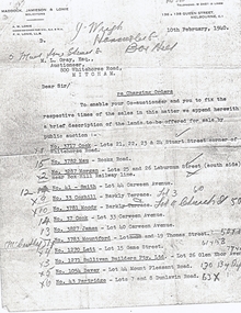 Whitehorse Historical Society Inc.
Document, Land Sales
... Land Sales... regarding charging orders for land sales.... Mitcham melbourne Document Document Land Sales Letter from A. M ...Letter from A. M. Lonie of Maddock, Jameson & Lonie, solicitors to M.L. Grey Esq , Auctioneer,Letter from A. M. Lonie of Maddock, Jameson & Lonie, solicitors to M.L. Grey Esq , Auctioneer, 800 Whitehorse Rd, Mitcham regarding charging orders for land sales.Letter from A. M. Lonie of Maddock, Jameson & Lonie, solicitors to M.L. Grey Esq , Auctioneer,cock, stuart street, blackburn, whitehorse road, mau, rooks road, mitcham, morgan, laburnum street, lots 25, 26, smith, carween avenue, lot 44, coghill, barkly terrace, lot 3, moody, church street, lot 4, cook, lot 33, james, lot 40, mountford, thomas street, lot 19, lett, game street, lot 15, sullivan builders pty ltd, glen ebor avenue, lot 26, davey, mount pleasant road, forest hill, partridge, dunlavin road, lots 7 & 8, wright, mcdowall street, lots 106 - 7, gibb, lot 9 -
Ringwood and District Historical Society
Envelope, Nunawading, Ringwood, East Ringwood Land Subdivision Sales, and Grid Map of Melbourne
... Nunawading, Ringwood, East Ringwood Land Subdivision Sales...Land Subdivision Sales - Nunawading; Land Subdivision Sales..., East Ringwood Land Subdivision Sales, and Grid Map of Melbourne ...Land Subdivision Sales - Nunawading; Land Subdivision Sales - East Ringwood; Land Subdivision Sales - Ringwood; Land Subdivision Sales - Grid map of Melbourne -
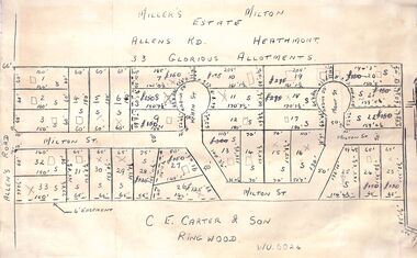 Ringwood and District Historical Society
Pamphlet - Land Sales Brochure, Miller's Estate , Heathmont
... Land Sales Brochure...Land sales pamphlet with hand-drawn 33 allotments...Land sales pamphlet with hand-drawn 33 allotments ...Land sales pamphlet with hand-drawn 33 allotments of the Miller's Estate, Allens Road, Heathmont. The new street is Milton Street with new courts Heath St and Mont St. Sold by CE Carter & Son, Ringwood WU6024. Maybe circa 1950s. -
 City of Greater Bendigo - Civic Collection
Administrative record - Land Sales, A. J. Mullet Government Printer et al, 1927
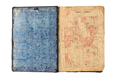
... Land Sales... clippings about land sales and auction details pasted in. Index page...Land Sales Administrative record Large portfolio style ...This type of album was made by agents auctioning and selling land.Large portfolio style album with dark green / black cloth cover bound with three large metal pins. Forty eight pages with twenty seven Department of Lands and Survey maps and newspaper clippings about land sales and auction details pasted in. Index page. Maps have handwritten notes and markings throughout in pencil and pen. Covers the County's of Gunbower and Tatchera. Includes a receipt slip with hand written notes on reverse on William Wallace & Co letterhead. city of bendigo commerce -
 St Kilda Historical Society
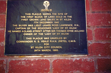
Photograph, Plaque marking the site of the first block of land sold in the first Crown Land Sales in St Kilda 7 Dec 1842, c. 1980s?
... the first Crown Land Sales in St Kilda 7 Dec 1842... in the first Crown Land Sales in St Kilda 7 Dec 1842. The buyer... of land sold in the first Crown Land Sales in St Kilda 7 Dec 1842 ...colour photograph unmounted (2 identical photographs)This plaque marks the site of the first block of land sold in the first Crown Land Sales in St Kilda 7 Dec 1842. The buyer was Lieut. James Ross Lawrence, R N, Captain of the Schooner 'Lady of St Kilda'. He named Acland st after Sir Thomas Dyke Acland, owner of "The Lady of St Kilda". This plaque was unveiled by Commander RS Veale RAN (retd) CMG for St Kilda City Council. 24 March 1985. -
 City of Greater Bendigo - Civic Collection
Administrative record - Land Sales, A. J. Mullet Government Printer, 1927
... Land Sales...Land Sales Administrative record Large portfolio style ...This type of album was created by agents auctioning and selling land.Large portfolio style album with black cloth cover bound with three large metal pins. Blue marbled pastedown endpapers. Seventy nine pages, seventy five with Department of Lands and Survey maps attached. No index page. Maps have handwritten notes and markings throughout in pencil and pen. Covers the Counties of Bendigo, Rodney, Gladstone and Talbot and Parishes of Kerang, Salisbury, Mandurang and Tarnagulla. Includes a hand written note on William Wallace & Co letterhead. city of bendigo commerce -
 City of Greater Bendigo - Civic Collection
Administrative record - Land Sales, Department of Lands and Survey et al, 1929
... Land Sales...Land Sales Administrative record Large portfolio style ...This type of album was created by agents auctioning and selling land.Large portfolio style album with green cloth cover bound with three large metal pins. One hundred and then pages with thirty three Department of Lands and Survey maps pasted in. Index page. Maps have handwritten notes and markings throughout in pencil and pen. Covers the Counties of Bendigo, Rodney, Talbot, Gunbower, Gladstone, Tatchera and Karkarooc, Shires of East Loddon and Huntly and Swan Hill District. -
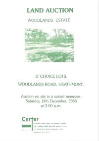 Ringwood and District Historical Society
Pamphlet - Land Sales Brochure, Woodlands Estate , Heathmont, 1985
... Land Sales Brochure... in green print. Woodlands Estate , Heathmont, 1985 Pamphlet Land ...Bifold pamphlet with picture on front, one inside plus plan of Woodlands Road sub division and locality plan on back page. All in green print. -
Ringwood and District Historical Society
Equipment - Printers Blocks, Borough of Ringwood - Printers Blocks for Land Sales (Notice, and Plan). c1850s-60s, 1858
... Borough of Ringwood - Printers Blocks for Land Sales... of Ringwood - Printers Blocks for Land Sales (Notice, and Plan ...1 Text readsWitness Our Only and Well Beloved Son Sir Henry Berkly Knight Commander of the Most Honourable Order of the Bath, Captain General and Governor-in-Chief of our said Colony and --------- of the same, at Melbourne, Victoria, aforesaid the Eleventh day of May and the Twenty First Year of the Reign and in the Year of Our Lord One Thousand eight hundred and fifty eight.1 Printers block no. top left 1598 Heading : VICTORIA - LAND PURCHASE 2 Printers Block Borough of Ringwood -
 Ringwood and District Historical Society
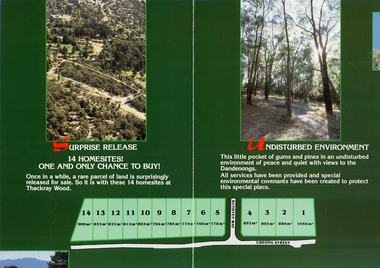
Flyer - Land Sale Brochure, Max Brown Real Estate, Double sided land sales brochure with map and landscape photographs regarding sale of 14 blocks of land comprising Thackray Wood, corner Cheong Street and Ruthven Way, Ringwood. Agent: Max Brown, Croydon, c.1977
... Double sided land sales brochure with map and landscape... sided land sales brochure with map and landscape photographs ...Sales brochure regarding sale of 14 blocks of land comprising Thackray Wood, corner Cheong Street and Ruthven Way, Ringwood. Agent: Max Brown Real Estate, 53 Main Street Croydon. +Additional Keywords: Max Brown Real Estate, 53 Main Street Croydon. -
 Ringwood and District Historical Society
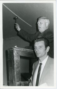
Photograph, A B Carter conducting land sales auction at Ringwood East. Circa 1970
... A B Carter conducting land sales auction at Ringwood East... land sales auction at Ringwood East. Circa 1970 Black and white ...Black and white photograph"Written on back of photograph" A B Carter at podium with gavel. Andy McLean alongside. Auction of land at Ringwood East.Circa 1970 -
RMIT GSBL Justice Smith Collection
Book, Parliament of Victoria, Prices and land sales control legislation of Victoria : being the Prices Regulation Act 1948, no. 5310, 1948
... Prices and land sales control legislation of Victoria... Russell Street Melbourne melbourne Book Prices and land sales ...Foreward by T. D. Oldham, M. L. A. Attorney-General for Victoriavictoria. prices regulation act 1948, price regulation -- victoria, vendors and purchasers -- victoria -
Koorie Heritage Trust
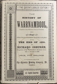
Book, Osburne, Richard, The history of Warrnambool, Capital of the Western Ports of Victoria, from 1847 (when the first Government Land Sales took place) up to the end of 1886, 1887
... Victoria, from 1847 (when the first Government Land Sales took... the first Government Land Sales took place) up to the end of 1886 ...A well documented account of many aspects of Warrnambool area from settlement to 1886. Chapter xii deals with the Framlingham Aboriginal Station. Including [1] folded leaf of plates containing a table.vii, 284 pages ; 19 cm.A well documented account of many aspects of Warrnambool area from settlement to 1886. Chapter xii deals with the Framlingham Aboriginal Station. Including [1] folded leaf of plates containing a table.warrnambool-history - 1847 - 1886., western district - victoria - history., aboriginals, victoria - history (1847-1886), framlingham - aboriginal station - history., massacres-history-warrnambool p.193-94 -
 Port Fairy Historical Society Museum and Archives
Book, Richard Osburne, The history of Warrnambool, capital of the western ports of Victoria, from 1847 (when the first government land sales took place) up to the end of 1886, 1980
... Victoria, from 1847 (when the first government land sales took... the first government land sales took place) up to the end of 1886 ...The history of Warrnambool, capital of the western ports of Victoria, from 1847 (when the first government land sales took place) up to the end of 1886 / by Richard Osburne Other Authors, Fraser, Malcolm, 1930-2015, (author of introduction, etc.) Tylee Memorial Collection368 pages, unnumbered and folded leaves of plates : illustrations (some colour), maps, portraits, plans ; 19 cmnon-fictionThe history of Warrnambool, capital of the western ports of Victoria, from 1847 (when the first government land sales took place) up to the end of 1886 / by Richard Osburne Other Authors, Fraser, Malcolm, 1930-2015, (author of introduction, etc.) Tylee Memorial Collectionvictoria. warrnambool, 1847-1886. facsimiles, government policy - initial period and protectionism., settlement and contacts - 19th century., mining industry - gold., race relations - violent - massacres, religions - christianity - missions., warrnambool (vic.) -- history., framlingham / purnim (w vic sj54-11), demography - census data, book -
 Victorian Aboriginal Corporation for Languages
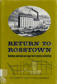
Book, D F Jowett et al, Return to Rosstown : railways, land sales and sugar beet ventures in Caulfield, 1978
... Return to Rosstown : railways, land sales and sugar beet..., land sales and sugar beet ventures in Caulfield The story ...The story of the attempt to establish the Rosstown industrial and residential complex in the Caulfield district, south-east of Melbourne, during the second half of the nineteenth century. The focus of the scheme was a major beet processing mill, the Rosstown Sugar Works. It also looks at the railways lines which serviced the sugar beet ventures in the Caulfield/Rosstown area.victorian history, local history, town planning, william murray ross, rosstown estate, rosstown railway -
Whitehorse Historical Society Inc.
Document, Land sales, n.d
... Land sales... Mitcham melbourne Document Document Land sales Handwritten notes ...Handwritten notes of land transactions 1855 - 1950, Crown Portion 109 bounded in part by Springvale and Burwood Roads.Handwritten notes of land transactions 1855 - 1950, Crown Portion 109 bounded in part by Springvale and Burwood Roads.Handwritten notes of land transactions 1855 - 1950, Crown Portion 109 bounded in part by Springvale and Burwood Roads.land subdivision, springvale road, vermont south, burwood highway, stanley road, mayne, alexander, james alexander, craig, mathew fergus, silas gordon, fankhauser, frederick william, clarence mervyn, mcnees, james, de leece, mackison, ferguson, samuel, mcgarrel, dennis, campbell, thomas, burrell, charles, meyer, jacob, huebner, otto, mihan, frederick, donaldson, john